Antiquarenbeurs Mechelen
Deelnemer
CartaHistoricaEdelweisslaan 13
3080 Tervuren
Belgium
Contact
Stanislas De PeuterTelefoon
+32 (0) 496 588 110 / +32 (0) 2 768 13 57 +32 (0) 496 588 110 / +32 (0) 2 768 13 57Website
www.cartahistorica.com
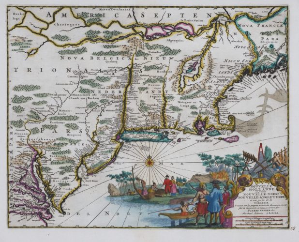
Dordrecht, Pieter Keur 1729


A superb copy of a Dutch States Bible in three volumes with 326 maps, prints and engravings
Biblia, dat is De gantsche H. Schrifture, vervattende alle de Canonijcke Boecken des Ouden en des Nieuwen Testaments. Door Last der Hoogh- Mog. Heeren Staten Generael vande Vereenighde Nederlanden, en volgens het Besluyt vande Synode Nationael, gehouden tot Dordrecht inde Jaren 1618 ende 1619. Uyt de Oorspronckelicke talen in onse Nederlandtsche tale getrouwelick over geset. Met nieuwe bygevoeghde Verklaringen op de duystere plaetsen, aenteeckeningen vande gelyck-Luydende Texten, ende nieuwe Registers over beyde de Testamenten. Ende door gemeene ordre der Nederlandsche Kercken verbetert van Druckfouten en Misstellingen die in den Eersten Druck gevonde worden. WITH: Icones Biblicae Veteris et N. Testamenti. / Figures du Vieux et du Nouveau Testament. Inventées et Gravées par Jan Luyken. / Print-Verbeeldingen der Historien des Ouden en Nieuwen Testaments. WITH: Historiae Celebriores Veteris (-Novi) Testamenti Iconibus Repraesentatae et Selectis Epigrammatibus exornatae in lucem olim datae a Christophoro Weigelio Noribergae.
Unieke set. 3 werken in 3 banden, (gegraveerde titelpagina, 19) 144, (1) 145-302 (2) 134, (12) 164 (2) 66 folia., Luyken: 62 folia., Weigel: (titelprent) 151, (titelprent) 108 folia.
Origineel Leer met ribben, rijkelijk met goud bestempeld, goud op snede en geciseleerde boekblokken, gebonden door de Tweede Stadhouderlijke Binderij in Den Haag, Folio H. 44,5 x L. 28 x B. 7-8,5 cm. Ruggen aan de onder- en bovenkant vakkundig gerestaureerd.
Zeer fraaie uitgave van de Nederlandse Bijbel in de Statenvertaling in drie banden, bestaande uit het Oude en Nieuwe Testament gevolgd door de Apocriefen. Doorschoten met de 6 dubbel paginagrote kaarten van Pieter en Jacob Keur, 61 genummerde, en dubbel paginagrote gravures, alle van Jan Luyken uit zijn Icones Biblicae. Daarbij het gehele werk van Christoph Weigel genaamd Historiae Celebriores bestaande uit 2 titelprenten en 257 gravures. Deze prentenserie is fraai en gedetailleerd gegraveerd. Onder de gravures staat de bijbehorende tekstverwijzing met een vierregelig gedicht in het Latijn en Duits. De gravures zijn voornamelijk gegraveerd door Jan en Casper Luyken en enkele door François Antoinne Meloni en Paul Decker. Het geheel is ingebonden door de Tweede Stadhouderlijke Binderij in drie zeer fraaie stempelbanden. De Tweede Stadhouderlijke Binderij was actief gedurende de jaren 1752-1782 in de stad Den Haag. De binderij heeft zijn naam te danken aan het feit dat zij veel banden inbonden voor de stadhouderlijke familie, voor dit doeleinde bezaten zij enkele stempels die exclusief hiervoor werden gebruikt, waaronder de kroontjes op deze set. Kenmerkend voor de banden is het rijkelijk met goud bestempelde patroon, de stempels zijn te herleiden naar de binderij met behulp van het standaard werk van Storm van Leeuwen. De stempels die gebruikt zijn voor deze banden zijn divers, op elk van de platten zijn 8 kronen weergegeven omringd door een levendig patroon van overwegend bloemmotieven en bladmotieven. De ruggen van de banden zijn tussen en op de ribben met goud bestempeld met een decoratief bloemenmotief, waarbij een vak is opengelaten voor de titel en de deelaanduiding. De boekblokken zijn met goud op snede en langs de randen geciseleerd met een een motief van bladeren.
3 works in 3 bindings, (engraved frontispiece, 19) 144, (1) 145-302 (2) 134, (12) 164 (2) 66 folia., Luyken: 61 folia., Weigel: (frontispiece) 151, (frontispiece) 108 folia.
Contemporary blind-stamped Leather with 7 raised bands, richly decorated with gilt, gilt-edged and gauffred text blocks, bound by the Second Stadholder?s Bindery in The Hague, Folio H. 44,5 x L. 28 x W. 7-8,5 cm. The spines are very slightly faded, and the spine-ends are skillfully restored.
A superb copy of a Dutch States Bible (Statenbijbel) in three volumes, containing the Old and New Testament followed by the Apocrypha. Interleaved with the 6 double-page maps by Pieter and Jacob Keur, 61 numbered, double-page prints, and the title print, all by Jan Luyken from his ?Icones Biblicae?, and the entire work of Christoph Weigel named Historiae Celebriores, containing 2 frontispieces and 257 engravings. This print series is beautifully and precisely engraved. Under the engravings is listed the reference to the accompanying Bible text and a 4-line long poem, both in Latin and in German. The engravings are mostly by Jan and Casper Luyken, and some by François Antoine Meloni and Paul Decker.
The Second Stadholder?s Bindery binds the work in three magnificent, blind-stamped bindings. The Second Stadholder?s Bindery was active in the years 1752-1782 in the city of The Hague. The bindery is so-called because it made many bindings for members of the Stadholder?s family; they owned special stamps for this purpose, among which were the crowns on this set. Typical for the bindings is the richly decorated pattern with gold tooling; the stamps can be traced back to the bindery with the help of the standard work of Storm van Leeuwen. The gilding used on the bindings is very diverse; on each board, 8 crowns are displayed, surrounded by a vivid pattern of mostly flowers and leaves. The spines are decorated with floral gilding between and on the raised bands, leaving some space for the title and volume indication. The text blocks are gilt-edged and near the edges gauffered with a design of leaves.
Literature: Eeghen, P. van & Kellen, J.P. van der (1905). Het Werk van Jan en Casper Luyken Deel II, p. 641-658 & 658-666 / Poortman, W.C. (1986). Bijbel en Prent. Deel II: Boekzaal van de Nederlandse Prentbijbels, p. 131 & 134 / Poortman, W.C. (1995). Kaarten in Bijbels, p. 193-203 / Klaversma, N. & Hannema, K. (1999). Jan en Casper Luyken te boek gesteld, p. 76 & 350 / Storm van Leeuwen, J. (1976). De achttiende-eeuwse Haagse boekband in de Koninklijke Bibliotheek en het Rijksmuseum Meermanno-Westreenianum, 298-311 & 453-456 / Storm van Leeuwen, J. (2006). Dutch Decorated Bookbinding in the Eighteenth Century Volume IIA, p. 164-173 & Volume III, p. 629-811. / Uit de Schaduw (2011),
Provenance: Twintig jaar Nederlands Genootschap van Bibliofielen, p. 328-331 private collection M. Roos, IJmuiden.
€ 25.000
View exhibitor's highlights